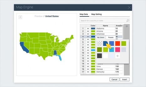
A step-by-step tutorial on how to create an interactive map with Visme, a free online infographic and presentation tool.
Get Started for FREE
Sign up with Facebook Sign up with X
I don't have a Facebook or a X account


 Your new post is loading...
 Your new post is loading...
Your new post is loading...
A step-by-step tutorial on how to create an interactive map with Visme, a free online infographic and presentation tool. 

Tom Cockburn's curator insight,
December 13, 2016 3:55 AM
Create your own maps

António Leça Domingues's curator insight,
December 19, 2016 6:44 AM
Criar um mapa interativo com Visme.

Bart van Maanen's curator insight,
December 19, 2016 10:02 AM
Mooie tool om een kaart van data te voorzien.
Sign up to comment

"If you're heading out on the road for your vacation this year, you'll probably get directions from a GPS or navigational system. Does that mean that the traditional map is a relic of the past? Mark Albert hits the road to find out."
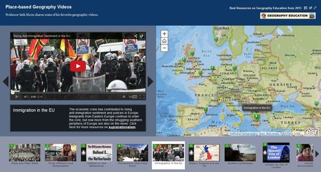
Professor Seth Dixon shares over 50 of his favorite geography videos in this online map http://bit.ly/KDY6C2

Melissa Marie Falco-Dargitz's curator insight,
November 3, 2014 12:02 PM
It was nice to see where everything was happening. I hope it gets updated to more current events. I wish we had something like this when we were looking at the invasion of Kuwait. 
Caroline Ivy's curator insight,
March 15, 2015 5:19 PM
Seth Dixon uses ArgGIS to juxtapose maps with the location a video is associated with.
This idea has crossed my mind before. Now, a video can be contemplated with the spatial accuracy needed. This connects events to a place, and can help students more fully grasp the geospatial distribution of events. 
Nita Ardi's curator insight,
January 14, 2019 12:16 PM
Great resource for classroom and information to get kids going.
|
From
www

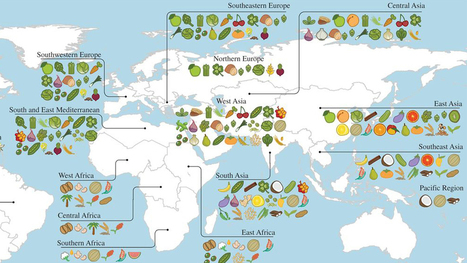
A new study reveals the full extent of globalization in our food supply. More than two-thirds of the crops that underpin national diets originally came from somewhere else — often far away.
Previous work by the same authors had shown that national diets have adopted new crops and become more and more globally alike in recent decades. The new study shows that those crops are mainly foreign.
The idea that crop plants have centers of origin, where they were originally domesticated, goes back to the 1920s and the great Russian plant explorer Nikolai Vavilov. He reasoned that the region where a crop had been domesticated would be marked by the greatest diversity of that crop, because farmers there would have been selecting different types for the longest time. Diversity, along with the presence of that crop's wild relatives, marked the center of origin.
The Fertile Crescent, with its profusion of wild grasses related to wheat and barley, is the primary center of diversity for those cereals. Thai chilies come originally from Central America and tropical South America, while Italian tomatoes come from the Andes.
Khoury and his colleagues extended Vavilov's methods to look for the origins of 151 different crops across 23 geographical regions. They then examined national statistics for diet and food production in 177 countries, covering 98.5 percent of the world's population. Via DrDids, Neil Bombardier, Fernando Gil, Dr. Stefan Gruenwald

Neil Bombardier's curator insight,
July 18, 2016 6:34 AM
Fascinating map of where your food comes from

"Thanksgiving resources for geography educators." http://wp.me/P2dv5Z-1lR
|